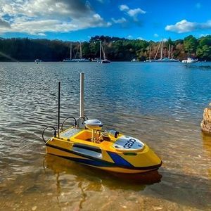
Oceanographic survey USV USV200 Multifaisceauxautonomousmonohullcarbon fiber


Add to favorites
Compare this product
Characteristics
- Applications
- for oceanographic surveys
- Guidance
- autonomous
- Type
- monohull
- Material
- carbon fiber
- Working speed
5 m/s
(16 ft/s)
Description
Drone bathymétrique Bali USV200 Multifaisceaux
BALI USV200 is a compact and easily transportable multibeam bathymetric drone, dedicated to high-density hydrographic and bathymetric surveys and structural images of the seabed. Ideal for environmental water surveys in harbors, inland waters, lakes, rivers, etc.
For all water bodies, even with remote access
Compatible with a wide variety of sensors as well as an automated winch and Lidar solution
“Flush” integration of multibeam echosounders for very shallow areas (15 cm draft).
This lightweight and robust USV is easy to use and transport by one or two people. The design significantly improves stability at high speeds.
Performs measurements in shallow water, 20 cm draft. Easy-to-handle and responsive with several speeds (up to 5m/s) depending on the requirements and navigation conditions.
The data is transmitted by radio link to the acquisition PC on land to check the results in real time.
Robust and durable carbon fiber hull with integrated well.
Remote controllable by the operator. With its integrated GPS, it can be used in autonomous mode by following a programmed route. This small and easy-to-handle drone is used for precision mapping of the seabed. Operations are completed much faster than with traditional boat surveys.
Catalogs
No catalogs are available for this product.
See all of CADDEN‘s catalogs*Prices are pre-tax. They exclude delivery charges and customs duties and do not include additional charges for installation or activation options. Prices are indicative only and may vary by country, with changes to the cost of raw materials and exchange rates.


