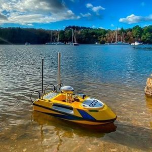
Boat depth sounder BALI V3for AUVs3Dportable
Add to favorites
Compare this product
Characteristics
- Application domain
- for boats, for AUVs
- Technology
- 3D
- Other characteristics
- portable
- Max. depth
200 m
(656'02" )- Supply voltage
12 V
Description
Compact and self-contained, BALI is an easy-to-operate, single-rod bathymetric measurement system. This lightweight bathymetry kit combines a single-beam bathymetric sounder with a RTK GNSS receiver. It processes and stores water depth measurements synchronized with a georeferenced position with centimeter-level accuracy, even in difficult areas. For advanced operators, the NMEA output uses common bathymetry software, such as QINSY, HYPACK, etc.
Easy to use: can be used with any smartphone, tablet or PC with Wi-Fi. No need for an external computer with its integrated web server
Can be combined with bathymetric softwares (ex: Hypack, QINSY)
Compatible with BALI USV100/USV200 marine drones
Ultra-portable and easy to set up by a single operator. The kit includes 2 cables and 3 poles, it is quick to assemble and can be easily carried in its case. Bali’s built-in NiMH battery provides up to 10 hours of use.
GNSS and UHF/GSM technologies are directly integrated into the antenna and allow to carry out surveys with real-time centimeter-level accuracy (RTK). The echosounder provides depth measurement with an accuracy of 0.2 %. Its transducer with an integrated temperature sensor adjusts the measured water height in real time.
The smart antenna is integrated with all the necessary telecommunication equipment to ensure a high level of connectivity to different types of radio networks: 3G, UHF and Wi-Fi
Hydrographic operations are very intuitive. No PC or hydrography software is required, a simple Smartphone is needed to connect via Wi-Fi to the internal web server
Real-time monitoring and wireless remote control is possible by connecting a PC, tablet or smartphone to the Wi-Fi
Catalogs
BALI V3
2 Pages
*Prices are pre-tax. They exclude delivery charges and customs duties and do not include additional charges for installation or activation options. Prices are indicative only and may vary by country, with changes to the cost of raw materials and exchange rates.


