- Ships and professional boats
- Service and Work boats
- Oceanographic survey marine drone
- OceanAlpha Group Limited

- Company
- Products
- Catalogs
- News & Trends
- Exhibitions
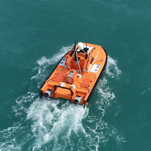
Hydrographic survey USV L20for oceanographic surveysfor bathymetry surveysautonomous
Add to favorites
Compare this product
Characteristics
- Applications
- for hydrographic surveys, for oceanographic surveys, for bathymetry surveys
- Guidance
- autonomous, remote-controlled
- Power source
- electric, hybrid
- Type
- catamaran
- Material
- aluminum
- Length
5.8 m
(19'00" )- Width
2 m
(6'06" )- Height
2 m
(6'06" )- Weight
2 t
(2 us ton)- Carrying capacity
Max.: 200 kg
(441 lb)200 kg
(441 lb)Min.: 200 kg
(441 lb)- Maximum speed
15 kt
- Working speed
5 kt
Description
1. When equipped with a USBL, it can be utilized for secondary positioning in marine geophysical surveys;
2. With a single-beam depth sounder onboard, it’s capable of conducting water depth measurements;
3. Operation is via remote control or command station, with switchable modes.
4. The remote control facilitates the transition and management of the vessel’s dual power systems, as well as the operation of the bow thruster;
5. A range of navigational modes are selectable, including standby, station keeping, track angle, bow direction, queue, path point, and external control, with the flexibility for users totoggle between different settings as needed;
6. The vessel features two independent lifting mechanisms, allowing for separate control. Users can remotely manage the lowering and retrieval of the equipment’s wet end, with real-time depth monitoring displayed directly on the software interface;
7. Video, radar, and sensor data are live-transmitted for monitoring and alerting;
8. Radar and AIS sensors enable collision avoidance and navigation warnings;
9. Software settings allow for the establishment of navigation speed limits and electronic fences to prevent the vessel from entering hazardous zones;
10. The software supports the import of obstacle data and design survey line files, such as Preplot files (formatted in .SPS and .shapfile), and offers coordinate system conversion capabilities, making it suitable for operations in any local coordinate system;
Catalogs
No catalogs are available for this product.
See all of OceanAlpha Group Limited‘s catalogsRelated Searches
- Professional boat
- Inboard professional boat
- Patrol boat
- Professional rescue boat
- Diesel professional boat
- Fireboat
- Autonomous surface vehicle
- Autonomous USV
- Remote-controlled USV
- Hydrographic survey USV
- Monohull USV
- Electric USV
- Oceanographic survey USV
- Catamaran USV
- Environmental measurement marine drone
- Alternative propulsion professional boat
- Mini catamaran marine drone
*Prices are pre-tax. They exclude delivery charges and customs duties and do not include additional charges for installation or activation options. Prices are indicative only and may vary by country, with changes to the cost of raw materials and exchange rates.


