
- Products
- Catalogs
- News & Trends
- Exhibitions
Navigation software Wayfindermanagementweatherfor ships
Add to favorites
Compare this product
Characteristics
- Function
- navigation, management, weather
- Applications
- for ships
Description
Why Wayfinder?
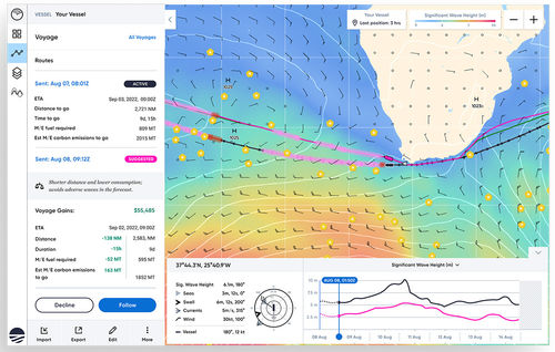
Wayfinder is a dynamic voyage guidance system that delivers the most efficient and least weather-restricted speed and waypoint recommendations to your fleet. The platform is powered by our global network of ocean sensors, which produces the best marine weather forecasts and informs detailed Vessel Performance Models (VPM). By incorporating your vessel’s specific business and safety constraints, Wayfinder continuously provides your operators and crew with the most optimized speed and routes possible.
Best Marine Weather Forecasts
Wayfinder is powered by the best marine weather forecasts, which we produce using our expansive network of sensors distributed across all five oceans. Each day, this network collects over 200,000 data points, real-time observations of waves, wind, currents, and other vessel resistance factors. We assimilate this data into our weather models — along with available satellite and in-situ data — to produce forecasts that are 40% more accurate than those of leading government centers. More data, less uncertainty, better outcomes.
Continuously Calibrated Vessel Performance
AdaptiveVPM™, Wayfinder’s data-driven Vessel Performance Model, acts as a digital twin of your vessel. The model uses a ship’s current physical condition and our marine weather forecasts to accurately predict vessel speed, RPM, and fuel consumption for any sea state encountered. Wayfinder incorporates actual performance data and real-time weather observations to dynamically recalibrate the model.
Related Searches
*Prices are pre-tax. They exclude delivery charges and customs duties and do not include additional charges for installation or activation options. Prices are indicative only and may vary by country, with changes to the cost of raw materials and exchange rates.

